
The Water Capital of Shizuoka, Japan? Places to visit in Mishima and Numazu to learn about water resources and the environment [Social Studies Field Trip].
Hello everyone.
Are you looking to gain a little more hands-on knowledge about water resources, but not sure where to go?
Yes, Mishima City, located in the Kanto region of Shizuoka Prefecture in Japan, is a great place to learn about water resources! You can learn about water resources in Mishima City, which is located in the Kanto region of Shizuoka Prefecture.
In this issue, we will introduce water resources and environmental study related spots in and around Mishima.
We hope you will find this information useful as a potential candidate for independent extracurricular learning, school or training.
It's also good for green tourism!
I usually recommend Mishima because it is full of nature and a place where just going out to play is enough to heal you.
So here you go.
Table of Contents
Mishima City became famous for its water resources because of a town development plan called the “Seseragi Project"
Mishima Ciryis a city with a population of approximately 130,000 located in the eastern part of Shizuoka Prefecture. It has long been known as the “City of Water” due to its location blessed with springs and abundant river water at the foot of Mt. In recent years, however, urbanization and industrialization have led to a serious decline in water resources, and Mishima City was no exception.
Mishima once again became famous for its water resources because of a town development plan called **"Seseragi Vision ”**. This plan was formulated in 1996 by the Mishima Chamber of Commerce and Industry as a commemorative project for its 50th anniversary, and advocated the promotion of urban development with the revitalization of waterfront space at its core in order to create a “city to walk in” and a “city to live in.
Specifically, the following initiatives were undertaken
- Culverted river is brought back above ground
- Establish water parks and walking trails along the riverbanks
- Promote streetscape development utilizing the waterfront landscape
As a result of these efforts, the central area of Mishima City has regained the appearance of the former “City of Water” and has become a popular place for citizens to relax. The improved waterside environment has also restored biodiversity, allowing fireflies, kingfishers, and other aquatic life to be seen again.
The success of this project in Mishima has not only helped the city of Mishima to promote community development utilizing its water resources, but it has also raised the awareness of its citizens and provided an opportunity for them to share the importance of water resources. (They will continue to promote this project in the future.)
This has brought Mishima City to national attention as a city famous for its water resources, and many inspection teams have visited the city. Mishima City's efforts are highly regarded as a reference for water resource conservation and urban planning in other cities.
Mishima City's efforts not only promoted community development utilizing water resources, but also raised citizens' awareness and provided an opportunity to share the importance of water resources.
Lots within walking distance! Places to see around Mishima Station
In this section you will find places you can explore and visit within walking distance.
Genbei River(げんべえがわ)
Genpei River: beautiful river where you can walk on paving stones.
If the river is not flooding here, it is an enjoyable river for children and adults to walk along, with pebbles that can be skipped across between rivers, etc.
Personally, when I think of water-related places in Mishima, I first think of this Genpei River.
Genpei River is a 1.5 km long river flowing through Mishima City, Shizuoka Prefecture. Located about a 5-minute walk from Mishima Station, visitors can enjoy beautiful scenery and abundant nature.
Stepping stones and wooden paths have been placed in the river, allowing visitors to enjoy a walk while feeling the murmuring of the stream. Visitors can enjoy the seasonal changes in scenery: cherry blossoms in spring, fireflies in summer, and autumn leaves in fall.
————————————————–
Name: Genpei River
Address: 10 Shibamoto-cho, Mishima City, Shizuoka Prefecture
(Google map:https://maps.app.goo.gl/uTq2EUSDS9BgwwHGA )
Opening hours: 24 hours
Closed days: None
Entrance fee: None
Official Web Site: https://www.mishima-kankou.com/spot/287/
————————————————–
Old Central Tap Water Source & Rakujuen Garden (旧中央水道水源&楽寿園)

A water supply facility built in the Meiji Era. It is designated as a national historic site.
And while you're at it, visit Rakujyuen.
This is another good place to go sightseeing without much walking from Mishima Station!
————————————————–
Name: Old Central Water Supply Source
Address: 3-16 Honmachi, Mishima City, Shizuoka Prefecture, 411-0855
(Google map: https://maps.app.goo.gl/cRv1t9agYfibvsi99 )
Access: within walking distance from Mishima Station
Opening hours: None (outdoors)
Admission and other required fees: None
Official website:https://www.city.mishima.shizuoka.jp/ipn025680.html
————————————————–
Mishima City History Museum(三島市郷土資料館)
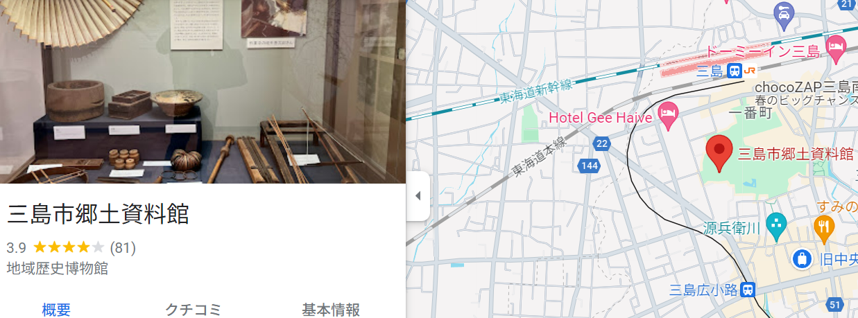
This museum exhibits materials related to the history and culture of Mishima. Materials related to water resources are also on display.
It is located in Rakujyuen, so if you visit there, you should also go in and see it!
————————————————–
Name: Mishima City Folk Museum
Address: 19-19-3 Ichibancho, Mishima City, Shizuoka Prefecture, 411-0036, Japan
(Google map: https://maps.app.goo.gl/t6rvZJcEF9R9GjTc9 )
Access:
Opening and closing hours: 9:00 a.m. to 5:00 p.m. (April to October)
9:00 a.m. - 4:30 p.m. (November - March)
(Admission to Rakujyuen is available until 30 minutes before closing.)
Admission fee and other necessary costs: Free of charge (however, a separate admission fee of 300 yen to Rakujyuen Garden will be charged.
(Free for children under 15 years old, free for students with student ID)
Official website:http://www.city.mishima.shizuoka.jp/kyoudo/
————————————————–
Kakita River & Kakita River Park(柿田川&柿田川公園)
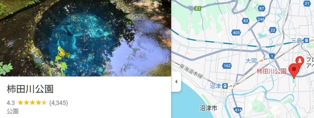
Kakita River: The longest spring-fed river in Japan, fed by subsoil water from Mt.
The only way to learn about Mishima's clean water resources is to go here first!
This shows how polluted the rivers in the city center are.
No, you can experience how clean Mishima's water is!
It should be shocking to see how different it is even within Japan.
————————————————–
Name: Kakita River & Kakita River Park
Address: 411-0907
71-7, Fushimi, Shimizu-cho, Sunto-gun, Shizuoka Prefecture (on Route 1)
(Google map: https://maps.app.goo.gl/xbZ21gL2xjrMZ64Y7)
Access:
Opening hours: None (outdoors)
Admission and other required fees: None
Official website:https://www.town.shimizu.shizuoka.jp/toshi/toshi00054.html
————————————————–
Mishima Grand Shrine[Extra]
If you are going to Kakita River, you should also visit the nearby Mishima Taisha Shrine!
Mishima-taisha is a lovely shrine that has undergone a major repair, as has the crocodile shrine.
Mishima-taisha is known as the first shrine in Izu Province and has been revered by many military commanders, including Minamoto no Yoritomo.
The precincts of the shrine include the main hall, which is designated as a national important cultural property, a hall of offerings, and a hall of worship.
The Mishima Summer Festival, held every July, is designated as a national intangible folk cultural asset.
The Mishima Taisha Shrine is deeply revered by merchants, industrialists, and fishermen, and the oldest written records of the shrine can be found from the Nara and Heian periods. It is a place with a long history, so if you are interested in visiting, please visit!
————————————————–
Name: Mishima-taisha shrine
Address: 2-1-5 Omiya-cho, Mishima City, Shizuoka Prefecture, 411-0035, Japan
Google Map: https://maps.app.goo.gl/iczbe6rAQounvSaK8
Access:
Train: 15 min. walk from Mishima Station on the Tokaido Honsen Line
Bus: Take Izu Hakone Bus from JR Mishima Station Bus Terminal to Mishima Taisha Bus Stop.
Car: 20 minutes from the Numazu IC of the Tomei Expressway
Opening and closing times:
Worship: 6:30 - 17:00
Shrine Garden: 9:00-17:00
Admission fee and other necessary expenses:
Worship: free of charge
Shrine Garden: Adults 300 yen, Elementary school students 150 yen
Official Website:http://www.mishimataisha.or.jp/
————————————————–
Kubo no Yusui (Kubo Spring) (窪の湧水)

Mishima offers opportunities to experience spring water in various places, and Kubono Spring is one of the most famous tourist spots in the area.
It is only a short walk from the station, so why not go there?
There are signs explaining the clean water and the surrounding environment!
He said that it is better to be careful in summer because of mosquito bites.
Bring mosquito repellent.
(Personally, I prefer mosquito repellent sheets because they are easier to take overseas)
————————————————–
Name: Kubo no Yusui (Kubo Spring)
Address: 2-1-5 Omiya-cho, Mishima City, Shizuoka Prefecture, 411-0035, Japan
(Google map: https://maps.app.goo.gl/ya4FStP26C3TJymQ7 )
Access:
5 minutes walk from Takehara bus stop by Fujikyu Shizuoka Bus
A little more than 30 minutes walk from Mishima Station
Opening hours: None (outdoors)
Admission and other required fees: None
Official Website:http://www.mishimataisha.or.jp/
————————————————–
Kano River (狩野川)
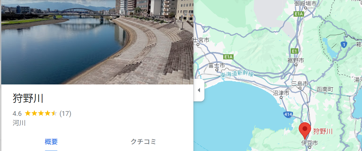
The largest river in the Fuji River system. Various nature observation can be done on the riverbed.
Please note the reading! (I also thought it was “Kari-no-wa” until I wrote this article)
Kano Riveris a first-class river flowing through Shizuoka Prefecture, and its main source of water is subsoil water from Mt. On the other hand,Kakita Riveris one of the tributaries of the Kano River and is the longest spring-fed river in Japan, known for its subsoil water from Mt.
quantity or volume of water
- Kano River: basin area 852㎢, total annual rainfall 1,800mm, flow approx. 5.5m³/s
- Kakita River: 4.4㎢ in area, total annual rainfall 1,800mm, flow approx. 0.2m³/s
The Kano River is more than 200 times larger than the Kakita River in terms of basin area and has approximately the same total annual rainfall, which means that its flow is more than 30 times higher.
water quality
- Kano River: BOD 1.0mg/L or less, COD 2.0mg/L or less, transparency 10m or more
- Kakita River: BOD less than 0.5mg/L, COD less than 1.0mg/L, transparency greater than 20m
Both the Kano and Kakita Rivers have good water quality, with BOD, COD, and transparency all meeting environmental standards. However, the Kakita River has lower BOD and COD and higher transparency, making it a better water quality river.
The Kano River is used for a variety of purposes, including agricultural water, industrial water, water supply, and power generation. The Kakita River, on the other hand, is used for agriculture and tourism.
Both the Kano and Kakita Rivers are inhabited by fish species such as sweetfish, iwana (char), and landlocked salmon. However, because the Kakita River is a spring-fed river, its water temperature is more stable and may be inhabited by more fish species.
The Kano River has a larger basin area and higher flow than the Kakita River. Both rivers have good water quality, but the Kakita River has better water quality. The Kano River is used for various purposes. In terms of the environment, both rivers are inhabited by fish, but the Kakita River is likely to be inhabited by more fish species.
reference information
- Kano River System: https://www.mlit.go.jp/river//basic_info/jigyo_keikaku/gaiyou/seibi/pdf/03_kano_gaiyou.pdf
- Kakita River: https://ja.wikipedia.org/wiki/%E6%9F%BF%E7%94%B0%E5%B7%9D
————————————————–
Name: Kano River (Kanogawa)
Address: 902 Nosaka, Izu City, Shizuoka Prefecture, 410-2411
(Google map: https://maps.app.goo.gl/ixu7BZNRdrda9zP17 )
Access:
(1)2 minutes on foot from Izu-Nagaoka Station
(2)5 minutes on foot from Shuzenji Station
(3)5 minutes on foot from Ohito Station
Opening hours: None (outdoors)
Admission and other required fees: None
Official Website: Ministry of Land, Infrastructure, Transport and Tourism Kano Riverhttps://www.mlit.go.jp/river/toukei_chousa/kasen/jiten/nihon_kawa/0501_kanogawa/0501_kanogawa_00.html
————————————————–
Kano River drainage canal (狩野川放水路)

Kano River drainage canal (狩野川放水路)is a man-made waterway that runs through Izunokuni City and Numazu City, Shizuoka Prefecture. It was completed in 1960 for the purpose of flood control of the main stream of the Kano River. It is approximately 3 km long, 50 m wide, 10 m deep, and covered with concrete.
Features of the Kano River Spillway
- This is an artificial channel for flood control of the main stream of the Kano River.
- It is approximately 3 km long, 50 m wide, and 10 m deep.
- It is covered with concrete.
- It consists of three tunnels and two open canals.
- It can channel floodwaters of up to 2,000 cubic meters per second.
- A tour path is provided within the discharge canal, which can be explored on foot.
History of the Kano River Spillway
- 1951 Construction started
- Construction suspended due to typhoon Kano River in 1958
- Completed in 1960
Role of the Kano River Spillway
- Flood control of the main stream of the Kano River
- Water Supply to Numazu City
- Sightseeing
Sightseeing along the Kano River Spillway
- A tour path is provided within the discharge canal, which can be explored on foot.
- From the spillway, visitors can enjoy views of the Kano River and Suruga Bay.
- Every year in late October, the Kano River Housuji Festival is held at the Housuji.
Information on Kano River Spillway
- Kano River Spillway:
- Kano
- The Kano River discharge channel is also recognized as a civil engineering heritage site.
- There are many sightseeing spots around the Kano River discharge channel, such as Kakita River and Mishima City.
To learn more about the Kano River Spillway, please refer to the information above.
————————————————–
Kano River drainage canal (狩野川放水路)
Address: Near Kuchino, Numazu City - Azunokami, Izunokuni City, Shizuoka Prefecture
(Google map: https://maps.app.goo.gl/RRZyPq9Zybhw3P3a8 )
Access:
Approx. 20 minutes walk from Izu-Nagaoka Station on the Izu Hakone Railway
Approximately 30 minutes from the Numazu IC of the Tomei Expressway
Opening and closing hours: Monday, Wednesday, and Friday from 10:00 a.m. to 4:00 p.m. Excluding national holidays and year-end and New Year holidays.
Admission and other required fees: Free
Official website:https://www.cbr.mlit.go.jp/numazu/river/shiryoukan/
————————————————–
Shirataki Park (白滝公園)
A small park where spring water can be observed.
The official tourism website of Mishima City also has an interesting article on the park, so please take a look at it!
Anyway, it is a very beautiful place with water and chi through the trees.
Just looking at the pictures is soothing!
————————————————–
Name: Shirataki Park (Shirataki Koen)
Address: 1-1 Ichibancho, Mishima City
(Google map:https://maps.app.goo.gl/A1oBWHU1pXCvUrCd8 )
Access:
5 minutes walk from Mishima Station
Approximately 7 minutes walk from Mishima-taisha shrine
Opening and closing time: None
Admission and other required fees: None
Official website:https://www.mishima-kankou.com/spot/480/
————————————————–
Numazu Area (沼津)
Numazu may give the impression of being quite far from Mishima, but in fact there are places within walking distance.
Numazu Port & Numazu Port Deep Sea Aquarium (沼津港&沼津港深海水族館)
The Swamp Figure Sluice Gate, which is next on the list, is also nearby and should go with you.
The place is quite famous as a regular tourist attraction, so be sure to enjoy it.
Dried fish and other foods are also available.
It is most famous for its food, but it also has the Numazu Port Deep Sea Aquarium, Coelacanth Museum, etc., which are quite enjoyable!
————————————————–
Name: Numazu Port
Address: 128 Senbon Minatomachi, Numazu City, Shizuoka Prefecture
(Google map: https://maps.app.goo.gl/GJNt5W3hZuoWb4t58 )
Access: JR Tokaido Shinkansen “Mishima” station, JR Tokaido Line “Numazu” station (Fuji/Shizuoka direction)
About 15 minutes from JR Numazu Station South Exit
Izu Hakone Bus Platform No. 1
Tokai Bus Orange Shuttle Bus Stop #2
Opening and closing hours: not specific, but it is recommended to go in the morning
Admission fees and other necessary costs: None, but each facility may have them, so gather information on the relevant facilities of the place you want to visit.
Official website:https://numazukanko.jp/feature/numazukou-tanoshimikata/top
————————————————–
Numazu sluice gate /沼津港大型展望水門 びゅうお Numazu Port Observatory Water Gate
It would be very nice to go see the sluice gate!
While visiting Numazu Port, stop by here as well!
It is a great power!
————————————————–
Name: Numazu Watergate /Numazu Port Large Outlook Watergate
Address: 1905-27, Honzu Senbon, Numazu City, Shizuoka Prefecture, 410-0867, Japan
(Google map: https://maps.app.goo.gl/JQt7UAwbC2isjuWu8 )
Access: Bus: Bus stop No. 1 or No. 2 at the south exit of JR Numazu Station, get off at Numazu Port.
Opening and closing hours: 10:00 - 20:00 (until 14:00 on Thursdays)
Admission fee and other necessary expenses:
Adults 100 yen
Child 50 yen (elementary and junior high school students)
Official website:https://numazukanko.jp/feature/numazukou-tanoshimikata/top
————————————————–
Senbon Beach Park (千本浜公園)
Senbonhama Park, located within walking distance of Numazu Port's large observation sluice “Buyo”, is a spacious park facing Suruga Bay. It is home to Senbon Matsubara, known as one of the most scenic spots on the Tokaido Highway, and is popular as a superb spot to enjoy the collaboration of the sea and pine forests.
The park has a well-maintained promenade that winds through pine forests, where visitors can enjoy a walk while feeling the sea breeze. Walking through the beautiful sunlight that shines through the gaps between the pine trees will refresh your body and mind.
Walking along the promenade, you can see the beautiful coastline of Suruga Bay and the majestic Mt. Fuji in silhouette against the deep red sky and sea will leave you with unforgettable memories.
Poetic and literary monuments by writers and poets who loved the area, such as Wakayama Makisui and Inoue Yasushi, are located in the park. A stroll while looking at these monuments will give visitors a taste of the history and culture of Senbonhama Park.
The park has a children's park where children can play to their heart's content, including a playground complex and swings. The park will be a great playground for children, where they can play while enjoying a view of the ocean.
Various events are held every year at Senbonhama Park. In addition to enjoying cherry blossoms in the spring and autumn leaves in the fall, the park is a busy swimming beach in the summer. During events such as the Numazu Port Festival, the park is lined with stalls and crowded with people.
Learn about the natural environment of the sea and pine forests.
Experience history and culture through song monuments and literary monuments
Children can play and interact with nature in the children's park
Beautiful coastline of Suruga Bay and views of Mt.
Participation in events such as the Numazu Port Festival
The boardwalk has some steps, so it is recommended to wear comfortable walking shoes.
In summer, there are many bathers, so be sure to take precautions against sunburn.
————————————————–
Name: Senbonhama Park
Domicile: Honji-Senbon 1910-24
(Google map: )
Access: 10 minutes by bus from JR Numazu Station South Exit (get off at Senbon Koen or Senbon Entrance)
Opening and closing time: None
Admission and other required fees: None
Official website:https://www.city.numazu.shizuoka.jp/kurashi/sumai/park/kouen/kobetu/senbonhama.htm
————————————————–
Numazu City Water Supply Management Center (Izumi Water Source) (沼津市送水管理センター(泉水源地))
The water source for the citizens of Numazu is located in Shimizu-cho, Sunto-gun, Shizuoka Prefecture. It is open to the public once a year!
It might be a good idea to go there during the public opening period here.
————————————————–
Name: Numazu City Water Supply Management Center (Izumi Water Source)
Address: Yawata, Shimizu-cho, Sunto-gun, Shizuoka, 411-0906, Japan
(Google map: https://maps.app.goo.gl/9tguQ6GYtmw5xCMUA )
Access: Nearest bus stop
Numazu City Spring Water Source
Approx. 187m walk, 2 min.
Bus Transfer Guide | Bus System/Routes
Shimizu Town Heated Swimming Pool
Approx. 416m, 5 min. walk
Bus Transfer Guide | Bus System/Routes
Nagasawakuchi [Shimizu Town, Sunto-gun].
Approx. 423m, 5 min. walk
Opening and closing hours: unknown, please contact official separately
Admission and other required fees: Unknown, please contact official separately.
Official website:https://www.city.numazu.shizuoka.jp/kurashi/sumai/suido/shokai/shisetu.htm
————————————————–
Shuzenji in Izu (a little far away) 修善寺
Shuzenji Onsen in Izu City, Shizuoka Prefecture, is the oldest hot spring in Izu. It is said that in 807, the high priest Kukai, visiting the area, was so moved by the filial piety of a young boy that he struck a rock in the river with a tokko (Buddhist implement) in his hand, causing the hot spring to gush forth. Today, visitors can only see the hot spring, but are not allowed to put their hands and feet on the rocks or take a bath in the hot spring.
It is said that in 807, the high priest Kukai visited the area and was so moved by the filial piety of a young boy that he struck a rock in the river with a dokko (Buddhist implement) in his hand, causing a hot spring to gush forth. It is said that this hot spring originated from Shuzenji Hot Spring and is the oldest in Izu.
Tokko-no-yu is located in the middle of the Shuzenji River (commonly known as Katsura River), and the bathtub is raised by assembling rocks and large stones from the foundation. In the past, visitors were allowed to bathe in the baths, but this is now prohibited because the baths are not positioned as bathhouses under the law. Currently, visitors can only observe the bathhouse, but are not allowed to put their hands and feet in it or bathe in it.
Shuzenji Onsen is a colorless, clear, tasteless, and odorless simple hot spring that is effective for treating coldness, stiff joints, autonomic instability, and insomnia. With a pH of 8.5, it is alkaline and has a cleansing effect that removes dead skin cells, and is said to be good for beautiful skin.
Dokko-Sen is a hot spring resort located at the foot of Mt. Dokko-Sen, and is very close to Maeyama, a famous cherry blossom viewing spot.
————————————————–
Name: Tokko-no-yu
Address: Shuzenji, Izu City, Shizuoka Prefecture
(Google map: https://www.google.com/maps/@35.7481531,51.3814418,17z?hl=fa )
Access: 15 min. walk from JR Shuzenji Sta.
Approximately 30 minutes by car from the Numazu Interchange on the Tomei Expressway
Parking lot available
Opening and closing hours: 24 hours a day, free to visit
Admission and other required fees: None
Official website:https://www.shuzenji-kankou.com/
————————————————–
Extra Edition] Nirayama Reverberatory Furnace (韮山反射炉)

The Nirayama Reverberatory Furnace is the remains of a gun emplacement built in the Edo period to defend the sea. It is one of the largest existing reverberatory furnaces in Japan and is designated as a Special Historic Site of Japan.
Completed in 1842, the Nirayama Reverberatory Furnace was built using the latest technology of the time. At the time, it played an important role in strengthening sea defenses in preparation for the arrival of foreign ships.
Visitors can tour the inside of the reverberatory furnace and watch a video that recreates the bombardment of the time. There are also many historical sightseeing spots nearby, such as the Nirayama Bamboo Grove and the Nirayama Egawa Residence.
————————————————–
Name: Nirayama Reverberatory Furnace
Address: 268 Naka, Izunokuni, Shizuoka, 410-2113, Japan
(Google map: https://maps.app.goo.gl/88itDYPvF4iCKY1Q8 )
Access: Approx. 1.8 km from Izu Nagaoka Station to Nirayama Reverberatory Furnace, approx. 30 min. on foot
Opening and closing hours: 9:00 a.m. - 4:30 p.m.
Admission and other required fees: 50 yen for children, 500 yen for adults (high school students and older)
Official website:http://www.city.izunokuni.shizuoka.jp/bunka_bunkazai/manabi/bunkazai/hansyaro/
————————————————–
Other natural attractions
Susono City: Goryu Falls (五竜の滝)
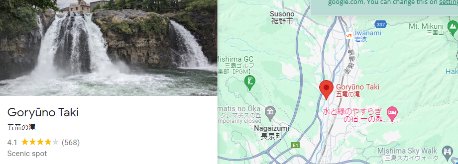
Goryu Falls is a scenic spot located in Susono City, Shizuoka Prefecture. It consists of five waterfalls cascading down a lava cliff from the Kise River, which collects melted snow water from Mt. The powerful landscape is approximately 100 meters wide and 12 meters high, and has been likened to the “dynamic motion of the five dragons.
The name “Goryu-no-taki” comes from the fact that the five waterfalls are named “Yukikai,” “Fujimi,” “Tsukimi,” “Choshi,” and “Saigoromo,” respectively.
Goryu Falls was designated a natural monument by Shizuoka Prefecture in 1936.
————————————————–
Name: Nirayama Reverberatory Furnace
Address: 268 Naka, Izunokuni, Shizuoka, 410-2113, Japan
(Google map: https://maps.app.goo.gl/88itDYPvF4iCKY1Q8 )
Access:
Opening and closing hours: 9:00 a.m. - 4:30 p.m.
Admission and other required fees: 50 yen for children, 500 yen for adults (high school students and older)
Official website:http://www.city.izunokuni.shizuoka.jp/bunka_bunkazai/manabi/bunkazai/hansyaro/
————————————————–
Hakone (箱根)
A tourist destination famous for its hot springs and natural scenery. There are also many attractions related to water resources, such as Lake Ashinoko and Owakudani!
It is not too far away (deep in the mountains), so if you can get there, you may want to extend your trip to Hakone.
Conclusion
How was the article?
The area around Mishima is truly blessed with water resources, so this is a place for everyone to visit, whether you are interested in water resources or just want to see water and relax!
And while you're at it, go eat some delicious eels.
For other articles on water resources, take a look here.


